- by foxnews
- 15 Mar 2025
‘Everything is saturated’: what’s driving the latest floods in eastern Australia
‘Everything is saturated’: what’s driving the latest floods in eastern Australia
- by theguardian
- 18 Oct 2022
- in news

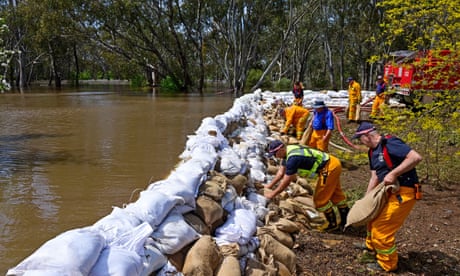
In the past week alone, heavy rain over Victoria, southern New South Wales and the northern parts of Tasmania has led to widespread flooding.
In Victoria, major flooding has occurred in the Murray, Wimmera, Campaspe, Loddon, Ovens, Goulburn, Avoca, King, Broken, and Maribyrnong rivers, and Seven and Castles creeks, according to the Bureau of Meteorology. In NSW, major flooding has affected the Barwon, Darling, Macquarie, Bogan, Lachlan, and Murrumbidgee rivers. There has also been significant flooding across the northern half of Tasmania, including in the Macquarie, Meander and Mersey rivers.
Dams have spilled for the first time in decades: Dartmouth Dam for the first time in 26 years, Lake Eildon for the first time in 28 years. On Monday afternoon, Thomson Dam in west Gippsland - Melbourne Water's biggest dam - was at 99.2% capacity.
There is unfortunately little reprieve for those in flood-affected areas, with heavy rain and storms forecast later in the week for eastern and south-eastern Australia.
When parts of the country's east coast flooded in February, scientists pointed to an "atmospheric river" that developed in the skies over Brisbane as a factor. Ten months later, what's driving the floods further south?
In a negative IOD - which has occurred in two consecutive years for the first time since reliable records began in 1960 - warm water concentrates in the eastern Indian Ocean, leading to moisture-rich air flows towards Australia.
"Moisture gets lifted up and it comes across," resulting in rain inland of the Great Dividing Ranges, Speer said. Last week, a low pressure system travelled eastwards over the continent.
Speer, who has worked as an operational meteorologist with the Bureau of Meteorology (BoM), added: "When you get these cloud bands that develop, they give rain to South Australia, western NSW and Victoria. Typically their source of moisture can either be from the Tasman Sea but also from the Indian Ocean."
Dr Nina Ridder, a research associate at the University of New South Wales' Climate Change Research Centre, sees similarities between this event and the floods along the east coast earlier in the year. "This front drew a large amount of moisture from the tropical Indian Ocean down to Victoria. That is similar to what we've seen in February and March in Queensland and NSW but that moisture [then] came from the Coral Sea," she said.
Ridder said she "wouldn't be surprised" if the current event was also driven by an atmospheric river.
Dr Margaret Cook is a lecturer at the University of the Sunshine Coast who specialises in the history of natural disasters."All the creeks and the rivers were very high before this rain in the last week, and the ground was pretty soaked," she said.
A cold winter in Victoria has hindered evaporation, and catchments have little capacity to absorb additional rain.
Victoria experienced flooding in similar areas in 2011, Cook said, adding there was also extensive flooding in 1974.
The area north of the Great Dividing Range is "a vast floodplain" she said. "That area is unbelievably flat. It's a very complicated system of rivers and creeks that all feed into the Murray-Darling system.
"The water is going to feed down and eventually end up at the Murray mouth at South Australia."
Riverine flooding can be deceptive, Cook said, because it can occur from the flow of water upstream even after rain has stopped. "People think the disaster is over, but in fact it's on its way," she said. "You get your sunny day with the flood coming through."
Increased flows from upstream areas can coincide with increased rainfall in a local area, exacerbating the problem, Ridder said.
More intense and frequent rainfall events have been linked to global warming. "This [event] is most likely linked to climate change," Ridder said.
- by foxnews
- descember 09, 2016
Neighbors react as viral 'Tunnel Girl' granted permit to continue digging massive bunker under home
"Tunnel Girl" in Herndon, Virginia, "finally" got her tunnel project approved after pausing the project due to a potential violation. Locals and social media users react.
read more


